Virtual Surveyor 6.1 Handles More Than Drone Data

Virtual Surveyor 6.1 has revolutionized drone surveying by eliminating the need for third-party applications, allowing users to handle on-the-fly projections directly within the software. This latest version enables surveyors to start projects from various data sets, including CAD files, and convert coordinates seamlessly during processing. With features like automatic section line creation and transparent layers for enhanced visualization, users can expect a faster and more efficient workflow. “Our goal with this version has been to make professional land surveyors more efficient,” says Managing Director Tom Op ‘t Eyndt. Discover how Virtual Surveyor 6.1 can transform your surveying experience!

Virtual Surveyor, the popular drone surveying software, has eliminated the need for clients to use third-party applications to prepare data for processing. Released this week, Virtual Surveyor 6.1 now handles on-the-fly projections that previously required a separate software package to set the data in the proper coordinate system.

“We have developed a completely new project experience for users of UAV data,” said Tom Op ‘t Eyndt, Managing Director of Virtual Surveyor nv in Belgium. “Version 6.1 will save our customers time and money once spent converting their drone data for processing in Virtual Surveyor.”

Virtual Surveyor has become popular among surveyors because it bridges the gap between UAV photogrammetric processing applications and engineering computer-aided design (CAD) packages. The software generates an interactive onscreen environment with UAV orthophotos and digital surface models where the surveyor selects survey points and breaklines to define the topography, creating highly accurate topographic products for CAD input up to five times faster than otherwise possible.

“Our value proposition has always been to enable surveyors to derive topographic information from drone data and deliver the light-weight meaningful CAD model that engineers need,” said Op ‘t Eyndt.

Prior to Version 6.1, users always had to start from an orthophoto and digital surface model (DSM). Now, surveyors can drag and drop all kinds of files into Virtual Surveyor: points, raster, vectors and point clouds. The point clouds are converted to a DSM for manipulation and processing, dramatically accelerating the time required to generate the CAD model.

“Not only is this faster, but it eliminates the expense of purchasing additional software,” said Op ‘t Eyndt.

Some customers asked to work only with a CAD file, he explained. Although they work with drone data most of the time, they occasionally had to create a surface or contours from a traditional survey. They asked if this could be done in Virtual Surveyor as it would save them from paying for a subscription to a CAD software.

Long-time Virtual Surveyor clients will find the entire project experience has been streamlined and improved with new capabilities in V6.1:

Start from any data set – Projects can now be initiated from Orthophotos, DSMs, Point Cloud or CAD files.

Convert coordinates on the fly – Users can input data in any coordinate system and convert it during processing to another system after the project has begun.

Developers of Virtual Surveyor have also added these features to V6.1: 

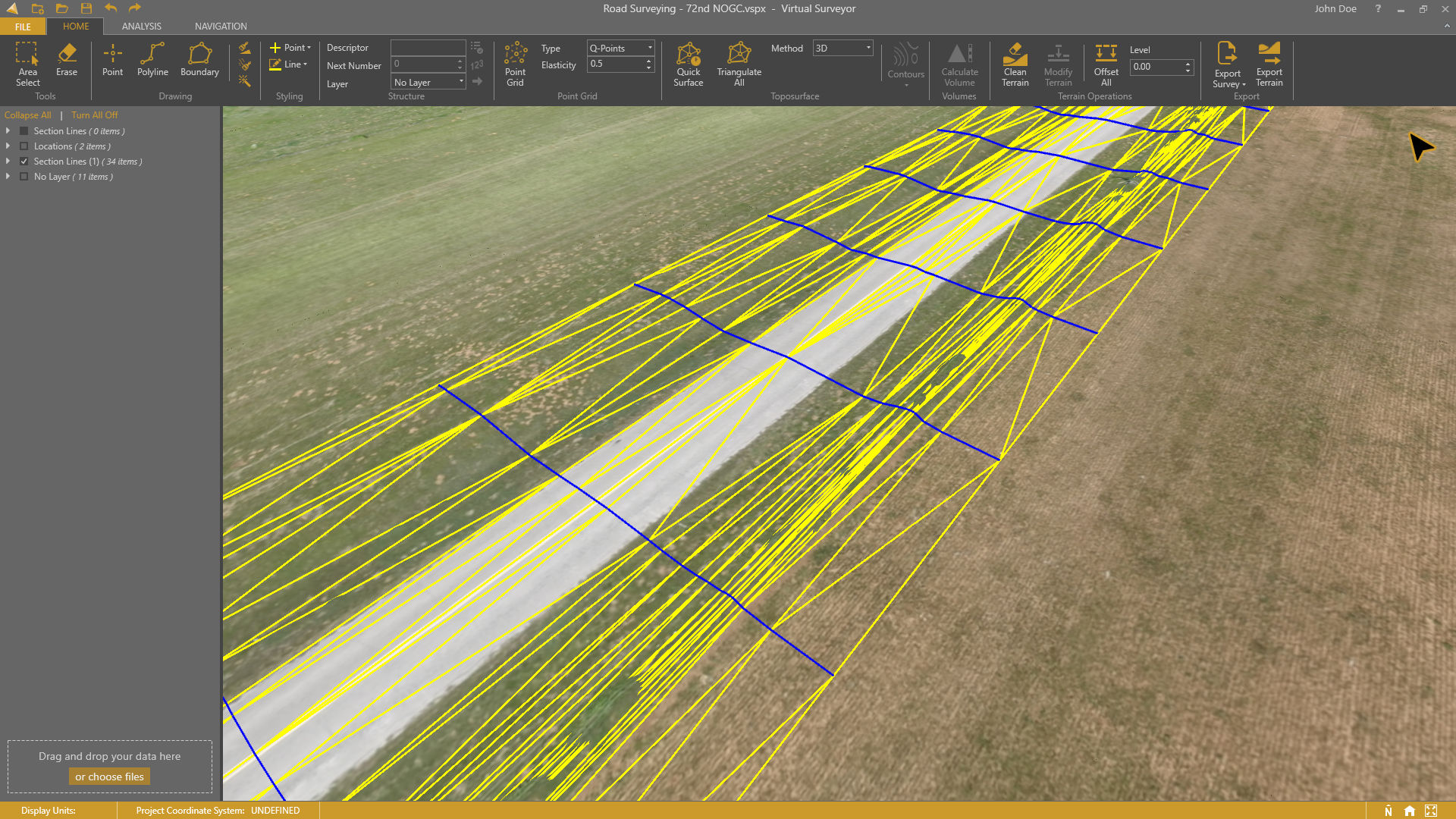
Automatic creation of section lines – V6.1 automatically generates sections from road surfaces to survey transportation routes in minutes.

Transparent layers – Users can add topographic or cadastral data to their project and view it through the orthophoto layer to annotate or draw boundaries.

“Overall, users will experience a faster processing environment in Virtual Surveyor 6.1 especially during complex tasks, such as making terrain modifications or calculating volumes,” said Op ‘t Eyndt. “Our goal with this version has been to make professional land surveyors more efficient.”

Current subscribers to Virtual Surveyor will see their software being updated automatically. 
Share:

More Posts

Virtual Surveyor Introduces Curb & Gutter Mapping in New Version of Drone Surveying Software

Virtual Surveyor has unveiled an exciting new feature in Version 7.6 of its drone surveying software: Curb & Gutter mapping. This innovative functionality allows surveyors to create precise CAD models of curbs and gutters, essential for effective water drainage planning. With the ability to input field measurements and extrapolate data, mapping becomes more accurate than ever. Additionally, the software includes enhancements like dynamic user experiences and easy mapping of circular features. Discover how these advancements can elevate your surveying projects and ensure engineers have the best baseline for designing safe road infrastructure. Read on to learn more!

Virtual Surveyor Drone Surveying Software Simplifies Workflow for Earthworks Monitoring at Construction Sites

Virtual Surveyor has unveiled Version 7.3 of its drone surveying software, revolutionizing earthworks monitoring at construction sites. This update streamlines the cut-and-fill mapping process, allowing construction managers to swiftly compare drone imagery with design plans. With features like the new Remove Object tool, users can easily eliminate extraneous items from surface models, ensuring accurate volume calculations. Additionally, the Spot Heights feature provides precise terrain elevation values, enhancing project oversight. Discover how Virtual Surveyor transforms construction workflows and empowers professionals to efficiently track earthworks progress, ensuring projects stay on schedule and within budget. Explore the latest innovations today!

Newest Virtual Surveyor Software Highlights Dangerous Slope Angles in Sand Pits, Quarries, Escarpments

Virtual Surveyor has unveiled an exciting new feature in Version 7.2 of its drone surveying software: the Slope Threshold lens. This innovative tool automatically highlights dangerous slope angles in sand pits, quarries, and escarpments, significantly enhancing operational safety. “With the click of a button, operators can see precisely where escarpments have exceeded user-specified slope angles,” says CEO Tom Op ‘t Eyndt. This update not only improves safety but also streamlines the surveying process, allowing users to create highly accurate topographic models faster than ever. Discover how these advancements can transform your surveying projects and ensure a safer working environment.

Send Us A Message

Great! We’ve received your information.